Download presentation
Presentation is loading. Please wait.

1
Support the spread of “good practice” in generating, managing, analysing and communicating spatial information Selecting a Mapping Method to Suit a Given Purpose By: Jon Corbett, Kasondra White and Giacomo Rambaldi Unit: M06U02

2
Introduction The choice of mapping methods is influenced by a number of factors. Mapping methods can be assessed against each factor using a series of criteria. Certain methods are more appropriate than others in some settings. The following presentation includes a description of participatory mapping methods.

3
Ground mapping Maps drawn on ground from memory Materials include anything available (such as plants, rocks, sticks, etc.) Easy to facilitate and low cost End product is impermanent
 Easy to facilitate and low cost End product is impermanent")
4
Image by Mount Kenya Environment Protection Project

5
Ground mapping: purpose Acquainting community members with maps Internal consumption Planning tool Raising awareness within community

6
Ground mapping: resources Low cost Specialised skills not needed No training required Does not require much time Supplies include sticks, stones, etc.

7
Ground mapping: setting Good where base maps are unavailable Appropriate where widespread distribution is not desired

8
Sketch mapping Freehand drawings Drawn from memory Includes key community-identified features Does not rely on exact measurements Not highly accurate

9
Sketch mapping in Malinau, Indonesia. Image by Jon Corbett.

10
Sketch mapping: purpose Good for informing internal discussions Provides a broad picture of issues and events Internal consumption Starting point for other maps Builds community cohesion

11
Sketch mapping: resources Low cost Technical skills are not required Does not require much time Supplies needed include: –large sheet of paper –pencils and possibly coloured pencils

12
Sketch mapping: setting Good where base maps are unavailable Allows for community control over map if apprehensive about widespread distribution

13
Transect mapping Spatial cross section of a community Includes: –geographic features –land-use types –vegetation zones Useful for analysing patterns of land use Only provides a limited perspective

15
Transect mapping: purpose Good for informing internal discussions Helpful for analysing land-use patterns Could be combined with 2D maps Primarily for internal consumption Useful as a starting point for other maps

16
Transect mapping: resources Low cost Easily facilitated No special skills are required Training requirements are limited

17
Transect mapping: setting Good where base maps are unavailable Suitable when apprehensive about widespread distribution Provides good perspective for low to high elevation transects

18
Scale mapping Presents accurate, geo-referenced data Distance measured on the map represents an equivalent distance on the ground Also referred to as base maps Community members may wish to: –draw information on existing scale maps –make scale maps using survey techniques

19
Drawing information on existing scale maps Local knowledge gathered through conversations can be recorded on maps Position of features determined by looking at natural landmarks Information can be incorporated into other tools Access to scale maps may be difficult in some countries

20
Images courtesy of Peter Poole ©/LEO

21
Making scale maps using survey techniques Scale maps can be made using equipment such as compasses and GPS devices Finished maps can be used to communicate local knowledge Should be viewed as a last resort – very expensive and time consuming

22
Drawing on scale maps: purpose Communicating information to decision makers Transposing GPS data Appropriate for determining quantitative information Good as a tool to advocate for change Enhancing community cohesion

23
Making scale maps: purpose May be a requirement of funders if scale maps do not already exist Appropriate when accurate and precise geographic data are required Useful when wishing to incorporate data into other mapping tools

24
Making scale maps: resources Expensive Time consuming Substantial requirements for equipment and time Technical expertise required (or a significant amount of time for training)
")
25
Making scale maps: setting Necessary when scale maps do not already exist Most appropriate where land information is not controversial Best when recording this information would not be dangerous

26
Participatory 3D modelling (P3DM) Scale relief models created based on topographic map Models made with cardboard and finished with wire, plaster and paint Geographic features depicted with pushpins Can be time consuming and transport can be difficult
 Scale relief models created based on topographic map Models made with cardboard and finished with wire, plaster and paint Geographic features depicted with pushpins Can be time consuming and transport can be difficult")
27
Image courtesy of Giacomo Rambaldi©/CTA

28
Participatory 3D modelling: purpose Informs internal discussions Can be presented in a museum Useful model that includes topographic information Enhancing community cohesion Land-use planning

29
Participatory 3D modelling: resources Relatively inexpensive Template of a topographic map is required Little to no technical skills required Some time will be required for creating the map and training

30
Participatory 3D modelling: setting Useful for internal community consumption Could be more culturally appropriate Well-suited to topographically diverse settings

31
GPS mapping A satellite-based positioning system Captures locations using coordinate systems (such as latitude and longitude) Although more affordable, may still be too expensive for some communities Computer will be required for storing and viewing points
 Although more affordable, may still be too expensive for some communities Computer will be required for storing and viewing points")
32
Image courtesy of A. Murphy, Global Diversity Foundation.

33
GPS mapping: purpose Used to store points and locate these on a map Surveying large areas accurately Adds accurate locational information Widely accepted format Appropriate for external agencies

34
GPS mapping: resources High cost (especially when computers are considered) Relatively time consuming Training is required Supplies needed include: –GPS device –computer –GIS software package, most likely
 Relatively time consuming Training is required Supplies needed include: –GPS device –computer –GIS software package, most likely")
35
Aerial and remote-sensing images Gathering images from the Earth’s surface using cameras on airplanes and satellites Features such as scale, orientation, coordinate systems and contour lines are shown Mylar transparencies can be overlaid for recording information Becoming easier to access

36
Image courtesy of Peter Poole©/LEO

37
Aerial images and remote sensing: purpose Good format for external audiences Excellent base map Useful in a wide array of situations Land-use planning Tool to advocate for change

38
Aerial images and remote sensing: resources Low cost if they already exist and are freely available Computer may be required if working with digital versions Little training required

39
Aerial images and remote sensing: setting Must already exist for an area Could be inappropriate if they reveal areas that community members wish to keep private Viewing large areas and patterns of resource use

40
Multimedia mapping: purpose Closer to traditional oral systems of knowledge transfer For external and internal consumption Enhancing community cohesion Teaching new and useful skills

41
Multimedia mapping: resources Can be expensive Could require a larger amount of training Supplies that may be desired include: –a computer –digital or film cameras –video cameras –audio recording devices

42
Multimedia mapping: setting Accessible regardless of language or literacy Identities may not be protected May not be available to all sectors of society

43
Geographic information systems (GIS) Computer-based systems that capture, manage, analyse and present spatial information GIS technicians work with communities Steep learning curve and relatively expensive
 Computer-based systems that capture, manage, analyse and present spatial information GIS technicians work with communities Steep learning curve and relatively expensive")
44
Image courtesy of Rachel Olsen

45
GIS: purpose Storing, retrieving, analysing and presenting local knowledge Supports discussion and decision-making process Appropriate for external audiences Useful for land-use planning

46
GIS: resources Expensive Time consuming A great deal of training will be required Technical expertise required Supplies required include: –a computer –GIS software package

47
GIS: setting Useful when fostering relationships between governments and decision makers Illustrating large scale patterns of land use

48
Internet-based mapping Uses web applications such as Google Maps and Google Earth Links to multimedia information Uses video, digital photos and text Information stored on computers Can reach a very wide audience Closer to traditional oral systems of knowledge transfer

49
Source: Google Maps - www.p3dm.org

50
Internet-based mapping: purpose Visualising and delivering rich multimedia community knowledge External and internal consumption Dispersed communities Bringing new skills to communities

51
Internet-based mapping: resources Expensive Some requirements may not be available Considerable training time Supplies required include: –a computer with an Internet connection (preferably high speed) –digital camera(s) –video equipment –audio recording devices
 –digital camera(s) –video equipment –audio recording devices")
52
Internet-based mapping: setting Appropriate for sharing knowledge widely May not be suitable for private information Bringing together dispersed groups

53
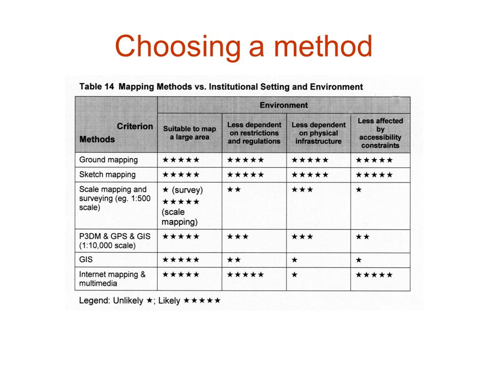
Choosing a method Community members have the final say Map makers should consider four factors: –the purpose of the PGIS activity; –the resources that are available; –the expected outcome; –the institutional setting or environment.

54
Choosing a method

Similar presentations


 Human Sensor Web project h2.0 Inform and Empower Initiative Human.>")


